- May 2, 2024

-
-
Loading
Loading
Out with wildfires, in with hurricanes. County emergency management preaches preparation.
Although two named storms, Alberto and Beryl, have already passed by Flagler before the official June 1 start of hurricane season, forecasts show that 2012 should be an average year for tropical storm systems. But to Flagler County Emergency Management Chief Troy Harper, that doesn’t mean all that much.
“Honestly, I don’t pay attention to the forecast,” he said. “Folks need to plan as if this were the year Flagler County is going to be hit. … You always have anomalies.”
For Harper, the biggest challenges to overcome before the Nov. 30 end of the season are residents’ complacency and making sure they leave early enough in cases of evacuation.
“People who were here and thought they survived a hurricane (in 2004),” he said of Hurricanes Charley, Frances and Jeanne, “well, they actually didn’t. They survived the outer band.”
Harper is careful to stress that Flagler County has never weathered direct impacts from a tropical storm — only brushes with bands. There were 28 named storms in 2005, but none hit Northeast Florida. The same with Hurricane Faye, in 2008, when Jacksonville and Titusville each got 30 inches of rainfall and Flagler got three.
“Don’t wait to start building a plan when you’re told to go,” he said. Check the weather every couple of days. Have an updated disaster kit ready. Make a plan. “It’s kind of like a recession … you don’t know you’re in it until you’re already in it.”
Citing Hurricane Andrew in 1992, Emergency Management Technician Bob Pickering agrees.
“In 1992,” he said, “it was a very slow season. … We actually waited all the way to the middle of August to come up with our first named storm. That storm was Andrew. Busy or slow season, it matters not. It only matters if one storm hits you.”
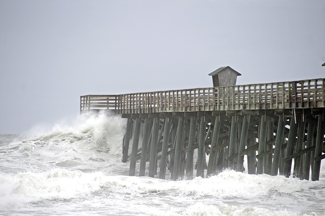
Worst-case scenario, Harper added, is that the storm surge alone from a hurricane could produce 25-foot-deep sea water extending over all of Flagler Beach and to Interstate 95.
“I think most people get it,” he said, “that they have to be prepared to be without power, potentially water, not able to leave their home. … Essentially it becomes a camping trip. You’re isolated from everything. What do you need to have? Do you have all those items in one location?”
This year, the county’s mantra is “Get a plan and get involved,” he added. Regardless of experience or physical ability, Harper said the county could use volunteers, which could be trained to work anywhere from in the kitchen at the Emergency Operations Center to call centers.
Residents who plan on long-distance evacuation should do so before hurricane warnings are issued. Hotel reservations should be made early, and alternative routes should be considered.
If evacuating on emergency orders, do so locally, to a shelter or hotel instead of out of the region or state.
For residents with pets, the Humane Society recently released a list of tips for animal evacuation, including putting a collar with visible identification on all pets in preparation of the storm season, keeping pictures of your pets on hand, compiling a list of pet-friendly hotels and making a pet emergency kit, including a three-day supply of food and water, medications, a leash, litter and comfort items.
For more, call 313-4200 or email [email protected].
BURN BAN LIFTED
Flagler County’s countywide emergency burn ban was lifted Monday, May 30, following heavy weekend rains from Tropical Storm Beryl.
All 13 burn ban signs placed around the county remain in place but are covered with tarp.
“I believe the rainfall amount received over the last several days may have been significant enough to help with the severe fire danger,” Flagler County Fire Rescue Chief Don Petito said. “Rainfall is in the forecast for the remainder of the week, and forecasters believe that the normal daily rain cycle should begin.”
As of Wednesday, May 30, the Keetch Byram Drought Index was an average of 406 across Flagler, with some areas as low as 388 and other areas as high as 654.
“We hopefully are coming out of a good fire season completely unscathed,” Emergency Management Chief Troy Harper said. “But we’re not out of the woods yet.”
With an average of 50 to 52 inches of rain annually, Flagler County has, as of May 31, recorded just short of 12 inches.
“We are in a multiyear, significant drought,” Harper said. “And to recover from a multiyear drought, you need multiple, multiple years of excess.”
If normal rainfall does not occur and conditions worsen, the ban may be reinstated.
“The most important thing to remember is never leave a fire unattended and always have a charged water hose nearby,” Petito added. “Florida law holds the person responsible for starting the fire liable for any damage from the fire.”
CODE RED
To sign up for Code Red, an automated phone program that issues local emergency and alert information — such as evacuation notices, boil-water notices and missing-child reports — visit www.flagleremergency.com, and click on the Code Red button on the right.
A new disaster-preparedness guide, made by Flagler County and Palm Coast, is currently being distributed and can be found online, at www.FlaglerEmergency.com.
To volunteer help during hurricane season, call 313-4200.
GIMME SHELTER
Flagler County Emergency Management has a roster of eight official shelter locations, any number of which could be open should conditions require. A full lineup of all locations is listed as follows:
Flagler Palm Coast High School
3265 State Road 100, Palm Coast
Indian Trails Middle School
5505 Belle Terre Parkway, Palm Coast
Bunnell Elementary School (special-needs shelter)
800 E. Howe Street, Bunnell
Wadsworth Elementary School
4550 Belle Terre Parkway, Palm Coast
Old Kings Elementary School
301 S. Old Kings Road, Flagler Beach
Belle Terre Elementary School
5345 Belle Terre Parkway, Palm Coast
Rymfire Elementary School
1425 Rymfire Drive, Palm Coast
Matanzas High School
3535 N. Old Kings Road, Palm Coast
TAKING NAMES
Less than a week into hurricane season, two named Atlantic Ocean tropical storms, Alberto and Beryl, have already passed by Flagler. A list of the rest of named storms for 2012 are as follows:
Chris
Debby
Ernesto
Florence
Gordon
Helene
Isaac
Joyce
Kirk
Leslie
Michael
Nadine
Oscar
Patty
Rafael
Sandy
Tony
Valerie
William
DANGER'S MY MIDDLE NAME
According to Emergency Management Technician Bob Pickering, there are other dangers to consider during hurricane season than just hurricanes.
“Rip currents kill more people every year than hurricanes, tornadoes and thunderstorms combined,” he said. “People should be good swimmers before setting foot in the ocean.”
To learn how to escape a rip current, visit www.ripcurrents.noaa.gov.
Pickering also warns of lightning strikes. “If you can hear thunder, you can be struck by lightning,” he said.
CATEGORY CACHE
Hurricanes are classified in five categories, depending on their wind speed and potential impact. Descriptions of each category are listed as follows:
Category 1: Winds of 74 mph to 95 mph, four- to five-foot storm surge, and minimal damage.
Category 2: Winds from 96 mph to 110 mph, six- to eight-foot storm surge, and moderate damage.
Category 3: Winds from 111 mph to 130 mph, nine- to 12-foot storm surge, and extensive damage.
Category 4: Winds from 131 mph to 155 mph, 13- to 18-foot storm surge, and extreme damage.
Category 5: Winds greater than 155 mph, 18 feet or higher storm surge, and catastrophic damage.