- April 19, 2024

-
-
Loading
Loading
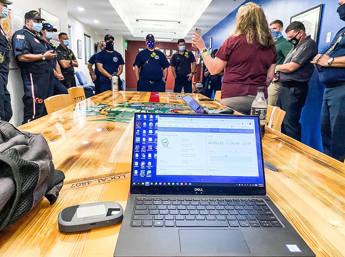
First responders across Flagler County are being trained to use a new search-and-rescue app that improves their safety, and allows them to share accurate data to improve the awareness of those conducting the search.
The GIS (geographic information system) based phone app, powered by ESRI’s “Quick Capture,” provides live tracking of individual search-and-rescue members, hazards reporting with the push of a button, and – provided there is cell tower coverage – instantaneous, accurate data sharing back to the home base.
The app’s creation was funded by the Florida Fire Chiefs Association under a contract with the National Association for Public Safety GIS. The app is currently being used in Georgia, the Carolinas, and Kentucky.
“This is a huge change just in one year,” said GIS Manager Darlene Pardiny during a joint training Tuesday, Sept. 1, with Flagler County and Palm Coast firefighters. “They are using a version of this (app) right now in Louisiana (and the aftermath of Hurricane Laura).”
When in use, the application marks continuously the travel path of the first responder, said GIS Analyst/UAS Coordinator Matt Adams. The marks are color-coded by squad and are linked to the individual carrying the phone.
“Your incident commander (IC) will know where you are,” Pardiny said. “If you disappear, your IC can track back to the last place you were. Safety is foremost.”
The push-button ability to report hazards, victim location, and other critical information, allows first responders to focus on the search.
“You will be able to focus on what you need to do as the boots on the ground,” Pardiny said. “Your IC will be able to handle the details from a command post, and provide you direction.”
Pardiny and Adams have already trained Flagler Beach first responders on the app, and are in the midst of two weeks of training within the county and Palm Coast to ensure training of all shifts. Flagler County Fire Training Chief Lenny Ensalaco participated in one of Tuesday’s session.
“This will be great for unified command (multiple agencies working together),” he said. “I think this will be great for our CERT volunteers. These are all new capabilities.”
The Community Emergency Response Team (CERT) Program educates people about disaster preparedness for hazards that may impact their area, and establishes neighborhood teams of volunteers to assist first responders.
“Use the app periodically to build familiarity before its use is required,” Adams said. “Let us know if there are tweaks we can make.”
The Flagler County Drone Team has the capability to utilize this app in conjunction with its drone GPS receiver to effectively guide first responders to particular points of interest.
The following first responders participated in this session of the Sept. 1 training:
Flagler County – Jesse Hunter, Tracy Farmer, Aaron Price, Kevin Feldman, Cody King, Dana Morris, Lenny Ensalaco
Palm Coast – Kyle Berryhill, James Neuenfeldt, Mark Davidson, Fortunato Damiano, Omar Kanaan