- April 19, 2024

-
-
Loading
Loading
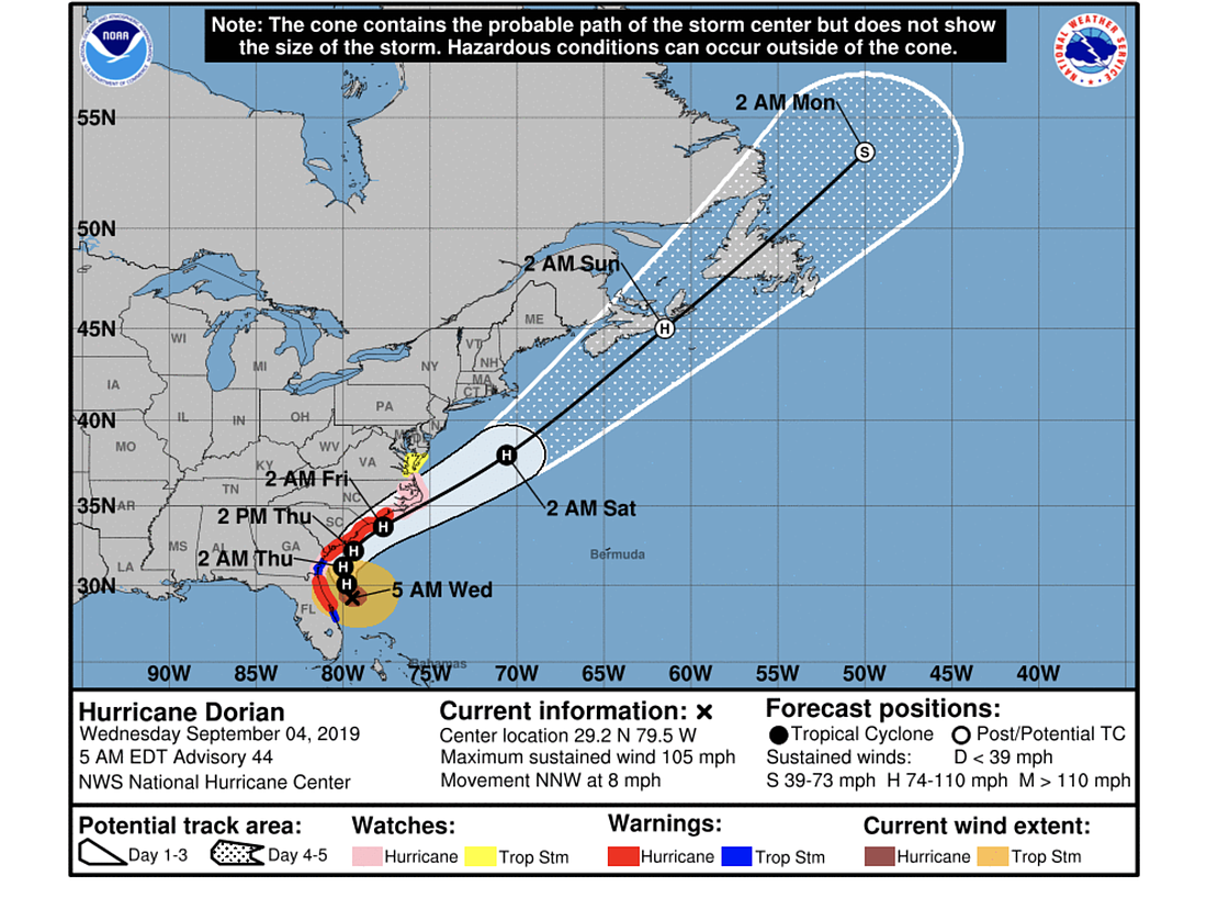
Hurricane Dorian, passing the Flagler/Volusia area Wednesday, Sept. 4, is expected to maintain its strength at a Category 2 for about two days, then slowly weaken, according to the National Hurricane Center's 5 a.m. Wednesday storm update message.
The Volusia/Flagler area is expected to see the worst winds it will get from Dorian by about noon Wednesday, with winds in the 40-50 mph range and gusts up to the 60s along the coast. But the storm will take considerable time to weaken, affecting the area with winds above 30 mph and 50+ mph gusts until about 8 p.m. Wednesday, according to National Weather Service forecasts.
As of 8:30 a.m., the WeatherSTEM station on the Hammock Dunes Bridge was showing winds of 19 mph and gusts of 26 mph. The station at Flagler Palm Coast High School showed winds of 19 mph and gusts of 31 mph, and the station at Belle Terre Elementary showed winds of 11 mph and gusts of 22 mph. The Palm Coast City Hall Weather Vane was reporting winds of 9 mph and gusts of 13 mph.
About 1,080 Flagler County households were without power as of 9 a.m.
Meanwhile, "NOAA Doppler radar data and reports from an Air Force Reserve Unit Hurricane Hunter aircraft indicate that Dorian's eye has become broad and less well-defined over the past several hours," the NHC message states. "The hurricane is still producing some healthy bands of deep convection that are causing winds of at least tropical storm force along portions of the northeast coast of Florida."
The warm waters the storm is traversing over the coming two days will maintain its strength, and it is predicted to be close to Category 2 strength until it nears or passes over North Carolina's Outer Banks, according to the NHC.
The storm's track is expected to stay about the same as indicated in the last several NHC predictions, paralleling the coast, making a gradual northward turn over the next day, then speeding up and turning northeast.
"Since the NHC track prediction continues to take Dorian dangerously close to the southeast U.S. coast, all interests from northeast Florida to the Carolinas should remain vigilant to the possibility of experiencing destructive winds, flooding rains, and life-threatening storm surges from this hurricane," the NHC message states.